onX Debuts ‘Dispersed Camping Layer’ on Digital Platform – RVBusiness – Breaking RV Industry News

MISSOULA, Mont. – Just in time for the summer camping season, onX, a leader in outdoor digital navigation, announced the launch of the industry’s first motorized Dispersed Camping Layer. This innovative feature makes finding legal, vehicle-accessible camping spots on roads and trails in National Forests easier and more intuitive than ever before, according to a release.
Dispersed camping is the practice of camping on public lands away from designated campgrounds or facilities. This type of camping has grown in popularity over the past five years because it offers a more remote, private, and natural experience away from the crowds, and doesn’t require reservations.
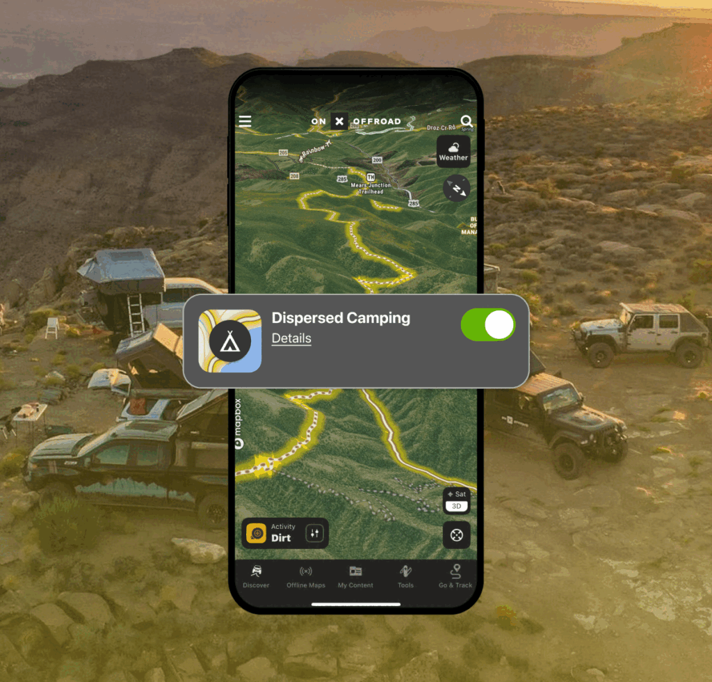
onX’s Dispersed Camping Layer is the first comprehensive source of motorized dispersed camping data, pinpointing nearly 140,000 miles (at launch) of roads and trails in the US National Forest System where the practice is allowed. When toggled on, the layer highlights these road and trail segments in bright yellow, and users can click on the road or trail for each area’s unique regulations.
Before the new layer, campers relied on two options to find motorized dispersed camping. They could consult Forest Service PDFs, which are the authoritative source but lack interactivity, or user-generated content apps that marked individual sites with varying degrees of accuracy. Neither option allowed campers to view camping information in the context of their route or navigational app. As a result, campers would cobble together information without a clear picture of what was actually allowed or accessible, leading to overcrowding, environmental strain, and even closures in some cases.
“We’re thrilled to introduce a powerful solution that addresses a real challenge our community faces,” said onX Offroad Content Manager Chris Cordes. “To develop the layer, we asked land managers how we could better equip outdoor enthusiasts to access dispersed camping areas and reduce their collective impact on public lands. By highlighting all the legal camping corridors, instead of pinpointing a limited number of marked sites, the layer helps users spread out, which helps disperse the environmental impact seen on popular sites pinned in other products. That’s a win for land managers. It’s also a win for outdoor enthusiasts, who, by spreading out, are finding the solitude they seek and simultaneously helping conserve outdoor destinations.”
At launch, the Dispersed Camping Layer includes vehicle-accessible corridors in US Forest Service lands in Washington, Oregon, California, Arizona, Nevada, Utah, Idaho, Montana, Wyoming, Colorado, and New Mexico. onX plans to expand the coverage nationwide later this summer and include dispersed camping on other federal lands in the future. The layer is currently available to onX Offroad Premium and Elite users.
For more information on the Dispersed Camping Layer and how to use this feature, visit https://www.onxmaps.com/offroad/app/features/dispersed-camping-maps
About onX
Founded in 2009, onX is a pioneer in digital outdoor navigation, developing software that helps inform, inspire, and empower outdoor recreationists. onX Hunt, onX Offroad, and onX Backcountry make up the company’s suite of apps and are built by explorers for explorers. Because off-the-beaten-path experiences are at the heart of what onX does, the company also leads initiatives to protect and expand access to public land. Since 2018, onX has worked with various partners to secure and improve public land access through direct funding and by supporting key legislation with data analysis and research.
Learn more: https://www.onxmaps.com/onx-access-initiatives