Hiking Near Las Vegas: The 26 Best Trails By Sin City
Although Las Vegas is known for its casinos and shows, it’s also great for outdoor adventures. The city is surrounded by state and national lands filled with mountains and picturesque desert landscapes. Plus, hiking near Las Vegas is incredibly accessible.
But if you’re stuck wondering where to go for an incredible outdoor experience, we got you covered. For this article, we sourced from trail aggregators Strava and AllTrails as well as park websites to find the best hiking near Las Vegas.
The Best Hiking Near Las Vegas
Desert View Overlook
The Desert View Overlook at Spring Mountain is a short hike out that’s easily accessible, including for wheelchairs, that offers expansive views of the Mojave Desert.
Lost Creek Trail
The Lost Creek Trail at Red Rock is an accessible trail offering a wide variety of sites, including pictographs, towering views, and from December to April, a seasonal waterfall.
Little Falls Trail
Although it’s considered “moderately” challenging, the Little Falls Trail at Spring Mountains is a short hike with about 360 feet of elevation gain. While you get some epic sites, it’s also dog friendly.
- Distance: 0.8 miles
- Elevation: 360 feet
- Location: Spring Mountains National Recreation Area
- Difficulty: Moderate
- Time: 30 minutes
White Domes Trail
The White Domes Trail at Valley of Fire is generally considered a short and easy hike, but it’s also great for bird-watching. The trail is just off White Domes Road, considered the most scenic road in the park.
- Distance: 1.1 miles
- Elevation: 177 feet
- Location: Valley of Fire State Park
- Difficulty: Easy

Hoover Dam Walking Tour
When you go on the Hoover Dam Walking Tour, you get to see how the Hoover Dam controls the flow of the Colorado River. Although you must pay for the tour, it’s also wheelchair accessible.
- Distance: 1.3 miles
- Elevation: 141 feet
- Location: Hoover Dam
- Difficulty: Easy
- Time: 30 minutes
Fire Wave Trail
The Fire Wave Trail in Valley of Fire is a short hike out to an amazing sandstone formation that, as the name suggests, looks like a wave of fire. The rock has swirling patterns of red, white, and pink sandstone. It’s largely considered one of the best hikes in the park.
- Distance: 1.5 miles
- Elevation: 236 feet
- Location: Valley of Fire State Park
- Difficulty: Easy
Ice Box Canyon Trail
The Ice Box Canyon Trail is literally one of the “cooler” hikes at Red Rock. The trail takes you through a cool, shady box canyon instead of exposed rock and open desert. However, it’s not the easiest hike as some scrambling is involved.
Wetlands Park Nature Preserve Loop
Located about 10 miles outside of the Las Vegas strip, the Wetlands Park Nature Preserve is a family-friendly loop with a paved and unpaved trail that cuts through both wetlands and a scenic overlook.
Calico Tanks
The Calico Tanks Trail at Red Rock is a short but physical hike. It offers a variety of terrain, including jumbled sandstone and even a hidden water pocket, and a great view of Las Vegas.

Seven Wonders Loop
The Seven Wonders Loop is an unofficial trail at Valley of Fire that includes the Fire Wave trail, which is one of the most photographed areas of the park.
- Distance: 2.3 miles
- Elevation: 209 feet
- Location: Valley of Fire State Park
- Difficulty: Moderate
Pine Creek Canyon Trail
The Pine Creek Canyon Trail offers a little bit of everything that makes Red Rock Canyon great. You’ll hike through a little bit of ancient forest, diverse plant communities, and monolithic canyon walls.
Keystone Thrust Trail
As you’ll hike through the Keystone Thrust Trail, you’ll see a colorful blend of rock thanks to some geological activity dating back about 65 million years ago.
Eagle’s Nest
The Eagle’s Nest trail begins at the Fletcher Canyon trailhead, a well-defined path through a dense variety of pine and juniper trees until you reach a steep hill, which marks the beginning of the Eagle’s Nest trail.
Cathedral Rock
With wildflowers blooming and butterflies fluttering, the Cathedral Rock trail is one of the most colorful hikes at Mount Charleston in the summertime.

Middle Oak Creek Trail
If you’re looking for an open desert trail, look no further than Middle Oak Creek Trail at Red Rock. You’ll not only get great desert views, but you’ll also see the Red Rock Escarpment.
Lone Mountain Loop Trail
The Lone Mountain Loop Trail is located about 20 miles northwest of the strip. It’s a great recreational area for Clark County residents, equipped with not just parks and picnic areas, but also outdoors and exercise.
- Distance: 3.2 miles
- Elevation: 738 feet
- Location: Lone Mountain Park
- Difficulty: Easy
- Time: 2 hours
Guardian Angel Pass
Off the beaten path, the Guardian Angel Pass is an unofficial trail at Red Rock Canyon. It’s considered one of the more difficult routes as it requires lots of scrambling and navigation.
La Madre Springs Trail
If you’re interested in seeing water and dense vegetation in the middle of the Red Rock Conservation Area, La Madre Spring Trail is for you. It’ll take you through fairly dense, and the pinyon pine, juniper, and scrub oaks.
First Creek Canyon
The beginning of the First Creek Canyon Trail is an easy walk through a desert valley, but the tail end, where you’ll find a little waterfall with cottonwood trees, gets a little rough.
South Oak Creek Trail
Unlike most trails at Red Rock Canyon, you’ll access the South Oak Creek Trail via a dirt road about 1.5 miles south of the Scenic Drive exit. It’s a great hike if you want to stop and picnic in a shaded area.
Turtlehead Peak Trail
When you’re hiking at Red Rock Canyon, the views don’t get much better than from the top of Turtlehead Peak. Although it’s one of the most accessible peaks, it’s also one of the more challenging on hot or windy days.
Wilson’s Pimple Loop
The Wilson’s Pimple Loop is another unofficial trail at Red Rock Canyon, which means it’s a nice place to explore. However, it’s also a popular spot for hiking, running, and dog walking.
White Rock Mountain Loop Trail
If you want to see colorful sandstone, several habitats, and gain the decline nearly 1,000 feet in elevation, the White Rock Mountain Loop trail at Red Rock Canyon is for you.
Bristlecone Loop
If you like long hikes, the Bristlecone Loop is for you. It has two entrances – an upper and lower trailhead – and the path is overall well traveled as it’s shared with hikers and horseback riders and dogs are welcome as well. However, Mount Charleston recommends hiking the trail from late spring through late fall as some areas become difficult or inaccessible due to snow.

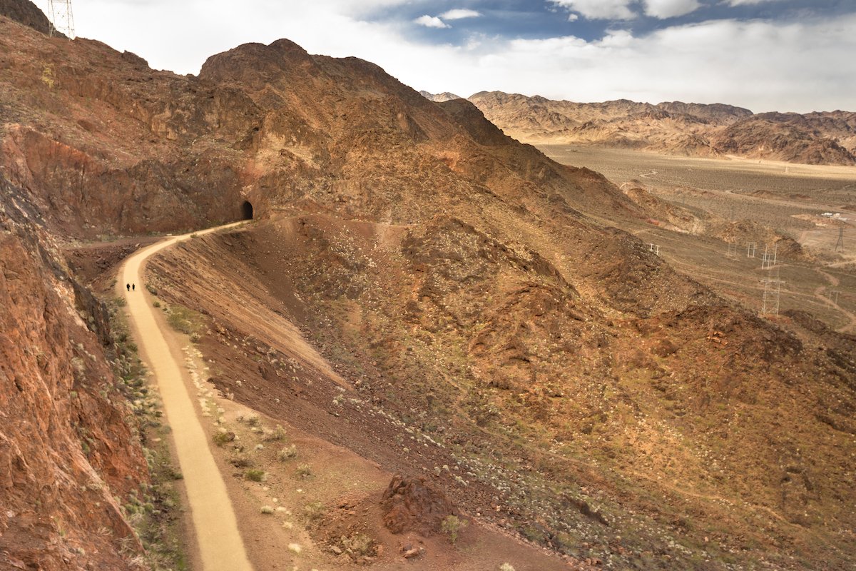
Railroad Tunnel Trail
The 8.2-mile Railroad Tunnel trail at Lake Mead is an easy route with multiple access points. It’s very accessible for hikers, mountain bikers, runners, those wheelchairs, and anyone wanting to walk with their dog off of a leash (in some areas).
Prospect Trail
At 9.3 miles, the Prospect Trail at Valley of Fire State Park is the longest trail on this list, but it also might be one of the more secluded (during quieter times of the day). It’s described as great for birdwatching and tough for hikers and runners as the terrain offers little to no shade.
- Distance: 9.3 miles
- Elevation: 784 feet
- Location: Valley of Fire State Park
- Difficulty: Moderate
- Time: 3 hours 30 minutes
Now that you know the best trails for hiking near Las Vegas, check out our other hiking and camping articles.