A River Runs Through It: The Border in the Big Bend
Growing up, one of my family’s favorite puzzles was a map of the United States. Each piece was one of the fifty states that fit neatly inside the outline of the country’s political boundaries. Alaska and Hawai’i floated in space somewhere off the southwestern coast of California, where I thought they were geographically located for some time after. The territories were left out completely, avoiding any complicated questions about what they were and how they might fit into the larger picture. Growing up in Virginia, the edges of this map seemed distant and uncomplicated, like I imagine it is for many people from the interior without personal ties to the border.
Travel to another country generally meant a journey by air: a vehicle that compresses time and space in such a way that I could board a plane, fall asleep or watch a few movies, and then arrive somewhere completely different without having to pass through, or even consider, whatever cultural, geographic, or political complexities transitioned me from this place to that one. Political rhetoric sometimes brought borders to the fore, but where it raised awareness, it also squashed dimensionality. It reaffirmed the border itself to be a supposedly concrete and straightforward line, and transformed its meaning into abstract concepts of citizenship, identity, and belonging.
I didn’t become interested in borders until I started crossing them overland: on foot, by bike, by boat, by train, and by road. Armed with the freedom of movement a US passport bestows and with some disposable income, I had the opportunity to see many. Soon, the physical borders themselves became the primary focus of much of my travel, the places on either side secondary. It was both physically and existentially fascinating and worth many long and circuitous detours, to see the tremendously varied infrastructure people had put in place to determine the here and the there.
One specific border, though, has held my attention the longest. The 1,200 miles of the US/Mexico border between the US state of Texas and the Mexican states of Chihuahua, Coahuila, Nuevo Leon, and Tamaulipas is the Rio Grande, the second largest river in the American west, which begins its journey in the San Juan Mountains of Colorado. River borders suggest a “natural” line, so unlike the arbitrary squares assigned to places like the Four Corners. Not so. According to the Treaty of Guadalupe Hidalgo, which established the Rio Grande as the southern border in 1848, the official boundary line falls in the deepest channel of the river. However, rivers, and desert rivers in particular, change course both gradually and rapidly. They overflow their banks, split apart, come back together, and find new tracks through which to carve their deepest waters. Remote parts of the Rio Grande were some of the last parts of the southern border to be surveyed, even after places like the Sonoran Desert, which are also remote and cut straight, impractical lines without any real regard for geography. In the years since, the river’s movements have led to territorial disputes often solved by infrastructure that wrestles it into submission. Much of the Rio Grande is now channelized in cement.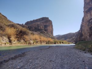
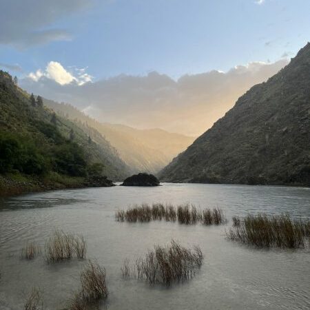
Several hundred miles of the Rio Grande are designated as a Wild & Scenic River. This stretch, loosely between the town of Presidio and the Amistad Reservoir, flows with a striking lack of physical infrastructure for either the southern border or a large river in the American West. It is also the part of the river called the Big Bend, abutting the national park, a state park, and several wildlife preserves in the United States and Mexico and ranging from moderately to unbelievably remote. From my interest in borders and my experiences traveling to so many, I believe deeply that each of the many forms a physical border can take has much to teach. After months on the Rio Grande in the Big Bend, I feel I am only just beginning to uncover everything there is to learn from this river as a border. The two first, and most simple lessons, are as follows.
For those of us who live far away from the US/Mexico border, our perceptions often come from hotly politicized discourse and accompanying images. There is a distant and unforgiving desert, a city strung with barbed wire, and the waves of the Pacific crashing against a giant wall. In the Big Bend, a road meanders along a river that appears neither wide nor deep and turns off into campsites with familiar friendly National Park Service toilets and a Visitor Center. Boat launches cut through thickets of cane that line the bank. I’ve canoed down stretches of the river before, camping in deep canyons, drifting back and forth across the deepest channel, and even took inflatable tubes down on a recent spring break trip. Turtles and javelinas splash across. (No one told them, I guess!) It is beautiful, breathtakingly so, and peaceful. It makes an obvious challenge to the perception that the border is already a single vision of militarization, or that this might be either possible or desirable everywhere.
At the same time, much hides in plain sight here, too. With a car, access to running water, and a national park map, the Chihuahuan Desert can feel like a friendly and accessible place. It is easy to forget, then, that without those things it can be an incredibly difficult space to traverse. The Big Bend is remote on the US side, but it is even more so in Mexico. Not all border infrastructure takes manmade forms, and the US has a history dating back to the 1990s of using the desert as homegrown spaces of “prevention through deterrence,” or, passage at the risk of hardship and possible death.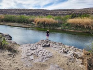
While recreation abounds from the US side of the border, this is not the shared recreative imaginings of the Waterton-Glacier International Peace Park. There are no casual boaters who launch from the Mexican side, nor campsites lining the banks. One small Mexican town called Boquillas, accessible by boat from the national park, sits along the riverbank. US citizens, Europeans, or anyone else from thousands of miles away who have visa-free access to both countries, can cross the river and back, eat tacos, and ponder the novelty of the experience. Residents of Boquillas without documents cannot legally cross the narrow, unfenced river that sits quite literally in the front yard, even though the nearest goods and services are in the United States. For many years, Boquillas residents could not cross at all, with or without documents. The border was closed between 2002 and 2013, after 9/11, out of concern that this distant Mexican outpost of several hundred residents with long ties to the US might suddenly become a national security concern. Most residents left the town during this period to seek work elsewhere. At first glance, the “wild” Rio Grande might seem to suggest something wonderous about a fluid border, and in many ways it does, but it is also a reminder that infrastructure, whether obvious or invisible, makes borders a boundary only for some, and manmade infrastructure is not the only way this is done.
The Big Bend is one of many wilderness recreation areas along the land borders of the United States. Others include Organ Pipe Cactus National Monument, Coronado National Monument, Amistad National Recreation Area, Waterton-Glacier International Peace Park, the Boundary Waters Canoe Area Wilderness, and many others. If outdoor recreation is an important tool for people to explore the boundaries of themselves and all the questions that come with that, I believe it can also be a tool to explore the boundaries of a country.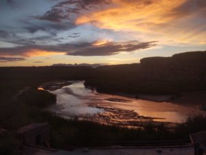
The post A River Runs Through It: The Border in the Big Bend appeared first on Wasatch Magazine.
Source: https://wasatchmag.com/a-river-runs-through-it-the-border-in-the-big-bend/