What’s Happening with the Canadian Wildfires? If You Love the Outdoors, This Smoke Map May Make You Anxious
This summer started with international news heavily focused on Canadian wildfires burning on the country’s eastern side. The media highlighted the smoke bound for the U.S. East Coast, leaving places like New York under a thick fog of what is essentially poisonous air.
As the East Coast smoke subsided, so did the coverage, but today fires continue to burn across Canada, and smoke continues to cover sections of the U.S.
The latest out of Canada focuses heavily on British Columbia, north of Washington State and Idaho, where dozens of fires are burning. As many as 35,000 people are currently evacuated. This summer has set a new record number of fires, with as many as 5,700 fires burning from Canada’s Atlantic to Pacific coasts. The fires have burned more than 53,000 acres.
Canada has called in their military to help combat the fires in the west. Officials hope some cooler forecasted weather over the next few days will help slow the spread.
Air Quality
However, this only tells part of the story.
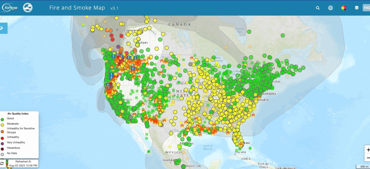
AirNow, the official U.S. partner for air quality and fire smoke data, has live maps to provide up-to-date information. Several fires are burning in the Pacific Northwest and the southwest United States. Much of the country is under moderate air quality, whether that’s smoke from Canada or fires in the U.S.

Recent heavy rainfall from Hurricane Hilary has temporarily cooled off the West Coast, but this summer continues to set record-breaking heat. When it comes to air quality, AirNow says it’s essential to monitor this, especially for sensitive groups like the elderly, young children, and others who are vulnerable. AirNow partners with the EPA, NOAA, the National Park Service, the CDC, and NASA to collect and provide the data.
You can check out the interactive map to learn more about the air quality in your neighborhood here.


